SKYSWEEPTM
Get The Most From
Your Weather Radar
Digital RF Technology, Inc. (DRFT) has been in the
process of creating the highest resolution, full range scale, weather
radar display system to date. The software, known as SKYSWEEPTM,
has been in development for the last four years with the main
broadcast test facility located at KWTV-9 in Oklahoma City, Oklahoma.
COMPETITIVE ADVANTAGE
HIGHEST RESOLUTION DATA
The SKYSWEEPTM
system generates the highest resolution data when operating at full
radar range than any other product available on the market today.
Because data resolution is a function of sample rate, the more often
a sample is taken the better the processed image will appear. In
turn, this will provide the meteorologist with more accurate
information for use in determining the most severe area of a
thunderstorm. By implementing special processes in computer software
code combined with high-end computer technology, DRFT’s
SKYSWEEPTM
system is capable of sampling radar intensity data every 150 meters
in range and every 0.08 degrees in azimuth while operating through
the radar’s full range. If operating in Doppler mode, the
specifications remain unchanged, and the effective range is reduced
to approximately 75 miles depending on the pulse rate of the
particular radar. The radar images produced by SKYSWEEPTM
will give the meteorologist a major competitive advantage when
warning the viewing audience of threats such as tornadoes or other
severe weather. In addition, no smoothing processes are required so
the data integrity remains at the highest possible level. Selectable
range integration is provided to enhance the display on long (>125
miles) scales when detailed analysis is not required.
Competing products operating at full
intensity range, typically 250 miles, only sample data every 1
kilometer. As the radar dish turns these products sample the data
every 1-degree in azimuth. The result is an image that has a
“blocky” appearance when zooming in closer and closer on
a particular storm. To minimize this appearance, steps are taken to
smooth the data into a form which makes it more appealing to the
viewing audience. Unfortunately, once any smoothing has been
applied, the integrity of the underlying data is lost, and the
meteorologist must rely more on preprogrammed algorithms to determine
threat areas. Even if smoothing does not take place, the 1-kilometer
by 1-degree resolution makes it very difficult to analyze a severe
storm.
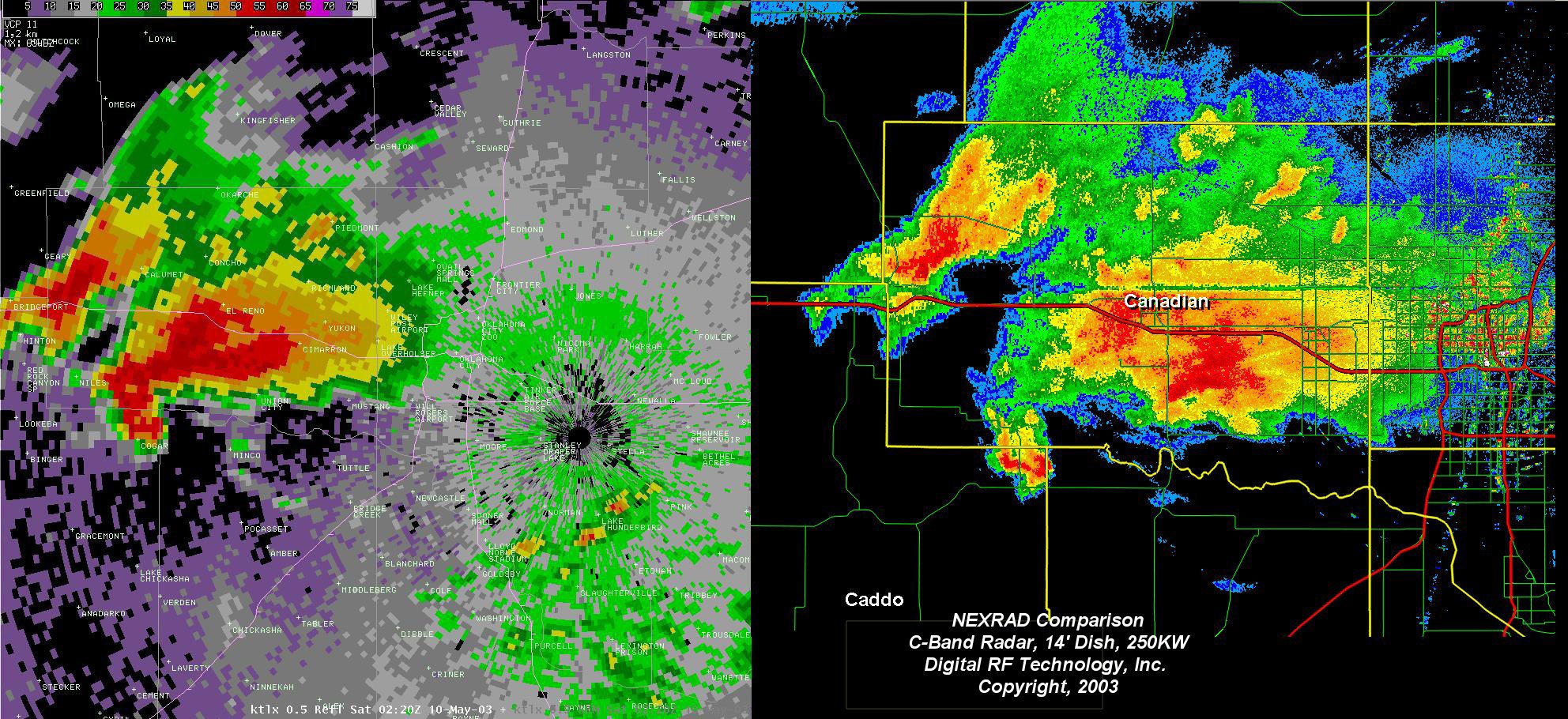
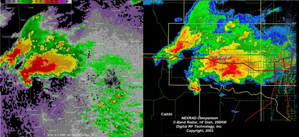
Below
is a comparison of a NEXRAD image (left) and the SKYSWEEPTM
system (right)
during
the May 9, 2003 tornado in Oklahoma City, OK. Click image for larger view.
MULTIPLE DISPLAY MONITORS
Another key advantage of SKYSWEEPTM
is the ability to view simultaneous Doppler and intensity radar data
on separate monitors. Each display position has two monitors that
can be configured “on-the-fly” depending on the user’s
needs. For example, one monitor can display Doppler data while the
other displays intensity data, or the user may view intensity data on
each monitor or Doppler data on each monitor. These changes can be
made with a simple click of the mouse. The user also has the
capability to independently pan or zoom one monitor without altering
the appearance of the other monitor. This is a very powerful tool
when analyzing two storm cells located in different parts of the DMA.
MULTIPLE DISPLAY POSITIONS
The SKYSWEEPTM
system has a third key advantage over other competitors in the
ability to have more than one display position connected to a radar
unit. Although a typical installation would be comprised of a
position located “on-set” and the other located
“off-set”, the software allows the second position to be
located anywhere a T1 telco circuit or LAN connection is available.
With two positions and their associated monitors, the meteorology
staff has four times the viewing capability. The second position
operates independently of the first, allowing four different storm
locations, county/state views, etc. to be at the station’s
disposal simultaneously. The system has been designed to accommodate
as many display positions as possible and is only limited to the
number of physical LAN or T1 connections. During the May 9, 2003
tornado in Oklahoma City, OK, a total of three display computers were
connected to the same radar unit without any system degradation.
DATA ARCHIVING
The SKYSWEEPTM
system has been designed to archive any radar data the user desires.
During a weather event the user simply initiates an archive command
and the data will be saved to the computer’s hard disk. After
the event has passed, the file can be transferred to a DVD drive
located on each display computer. The most important characteristic
of this data is the fact that it is recorded in raw radial form.
Unlike other systems that save only the radar screen images, the
SKYSWEEPTM
system archive process ensures the actual radar data integrity is
maintained. These saved sessions can be replayed at a later date and
will be displayed on the computer screens as if the radar itself was
sending information. The user can pan, zoom, stop or rewind the data
as desired. This is an especially powerful tool for creating
promotional material, training new talent or analyzing past severe
weather events.
COMPONENTS
•Street Level Mapping
• Storm Track and Time of Arrival
• Radar Control
• HDTV Ready
• Website Image Upload
Real World Testing
The first television station to put
the SKYSWEEPTM system to the test was KWTV-9 in
Oklahoma City, OK. This location was chosen for two critical
reasons: 1) Oklahoma has some of the most severe weather in the
United States and 2) the meteorological staff has the experience
necessary to analyze the most challenging storms. Chief Meteorologist
Gary England has been on the air at KWTV for over 30 years and is an
expert on severe weather. When he saw first-hand how the SKYSWEEPTM
system performed during a tornado outbreak on May 9, 2003, his
response was simple and to the point:
“It
was the most incredible radar presentation I had ever seen.”
Gary
England, KWTV-9
NBC5 in Dallas/Ft. Forth, TX was the
second station in the United States to benefit from the SKYSWEEPTM
system. DRFT acted as general contractor on their new 1MW radar
project and integrated the SKYSWEEPTM system to
maximize their capital investment. This combination of high
resolution and high power has given NBC5 a distinct competitive
advantage in the marketplace.
If you would like an on-site
demonstration to see first-hand how the SKYSWEEPTM
system can set your station apart from the competition, please
contact us at 903.872.8306.
Download a Word Doc of This Page Here
|